There’s a popular series of cycle guides called the ‘Lost Lanes’ – an evocative title as everyone wants to ride on quiet forgotten lanes preferably through unspoiled country. In many ways the lanes of south Shropshire and mid-Wales are the original lost lanes where you can ride for hours in wonderful country with very little traffic. This 230 km ride takes in some of the best of these lanes between Shrewsbury and Aberystwyth. From Rhayder it follows the popular Sustrans route NCR 81 Lon Cambria.

Head off southwest out of Shrewsbury. Once out of town the riding is along fairly quiet lanes through Hook-a-Gate and Annscroft to Pontesbury, following National Cycle Route 44 (although it’s not always clearly marked). From Pontesbury follow the lanes northward to Westbury. From Westbury head through Vennington to start the steady climb up Long Mountain which is exactly what it says – long in both ascent and descent. From the crest ignore turnings to Welshpool and head down to Forden and then to Montgomery with its fine castle and small but perfectly formed market square with a cafe that’s worth a stop.

Leave Montgomery on the Bishop’s Castle road – the B4385. Cross the the A489 and about a mile later turn right onto a lane heading towards Bishop’s Moat. This is also signed National Cycle Route 44. Another long and sometimes steep (15%) climb gradually brings you onto the Kerry Ridgeway, an ancient drovers road where there are views into Wales on one side and Shropshire on the other. There’s a fast descent to the quirky market town of Bishop’s Castle which no longer has a castle but does have a great selection of pubs, the 3 Tuns Brewery and a campsite with excellent views over the Shropshire Hills.

From Bishop’s Castle take the main road A488 for a couple of miles to Colebatch and then turn right and climb steeply through woodland to Cefn Einion. Continue to Bicton and then into Clun which has impressive castle ruins above the river.

From Clun another steep climb takes you out of the village, through Obley to Hopton Castle, notable for its siege during the Civil War.

Head south from Hopton Castle through Bedstone and Bucknell and then take lanes that follow the River Teme into the Welsh market town of Knighton. From Knighton follow the Sustrans’ Radnor Ring route (National Cycle Route 825) for the next 30 miles to Rhayader along some of the quietest lanes in mid-Wales.

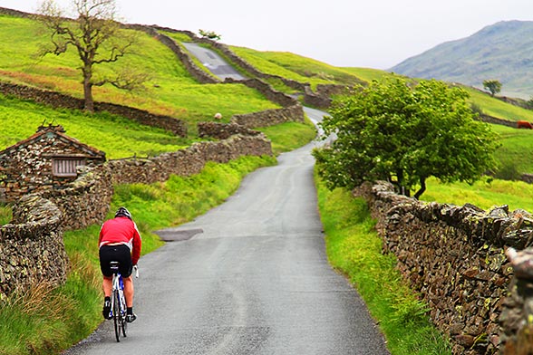
The route takes you through Knucklas, crosses the A483 north of Llanbister and then winds its way through Abbey Cwm Hir to Rhayader. This is remote country and you are likely to see as many red kites as cars on some sections. The climbs are tough but the rewards are wonderful views. At times the route looks like it’s just a track to a farm but it’s all on road, albeit with grass growing on some of them, and has the occasional gates to open and close. The wooded valleys and farmland give way to moorland and forest as you head towards Rhayader with great views of the hills of mid Wales. There’s hardly any villages between Knighton and Rhayader so stock up before you leave Knighton.

There’s a fair bit of climbing but it’s worth it for the ever changing scenery

Rhayader is a busy small market town with a campsite, pubs and food shops. From Rhayader you ride through the Elan Valley past reservoirs and gradually climbing onto the high moorland at the end of the valley. This route follows the NCN 81 from Rhayder to Aberystwyth


From Rhayader follow the NCN Route 81 – it’s fairly well signed all the way to Aberystwyth although it’s still useful to have a map or GPX download as well. There’s a cycle track from Rhayder to the beginning of the Elan Valley which also continues past the first couple of reservoirs, After that it’s minor roads on the west of the reservoirs until the head of the valley,

After the last reservoir there’s short steep section that brings you onto the mountain road to Aberystwyth.

From here it’s largely downhill all the way to the coast – very enjoyable riding on the first part of the descent towards Ysbyty Ystwyth. To start you’re riding in open moorland and following the River Ystwyth as it heads to the coast then gradually the road becomes more enclosed and wooded, passing old mine workings on the way.

The final section to Aberystwyth on the NCR 81 includes a section on a rail trail. To start with it’s a bit discontinuous so you need to keep a look out for the NCR 81 signs, have a GPX download or have the Sustrans NCR 81 map.

Aberystwyth is an attractive coastal town and a place to spend a bit of time before catching the train back to Shrewsbury and connections beyond.
Practicalities
Travel
Shrewsbury and Aberystwyth are well-served by trains. Or drive to Shrewsbury, leave the car and get the train back from Aberystwyth. At the time of writing (August 2022) Transport for Wales trains don’t require advance booking of bikes.
Route/maps
Sustrans maps are useful. The Lon Cambria map for the section from Rhayader to Aberystwyth and the Radnor Ring map for the section from Knighton to Rhayader. Alternatively plot the route using Cycle.travel or similar apps to create a GPX file and use a larger scale road map to provide an overview. OS maps are also useful, particularly for the Shropshire section.
Accommodation
There are campsites at Bishop’s Castle , and Clun YHA in the Shropshire section of the route. At Rhayader there is the Elan Village campsite – about 2.5 ml miles outside of Rhayader – and a Camping & Caravan Club site in Rhayader itself (not clear if non-members can use it).